Victoria · District atlas
Electoral districts
Victoria’s lower house is divided into 88 single-member districts. Each elects one member of the Legislative Assembly by preferential voting. The same geography is nested inside 8 Legislative Council regions (8 × 11 = 88).
Legislative Assembly Legislative Council Region atlas
Map-first atlas with area and history — not linked from the main menu. For 2026 candidacies, use the Assembly index.
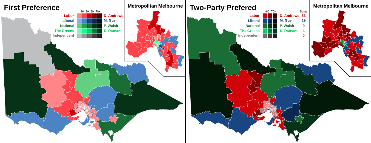
Map of Victoria’s districts
Geographic map of the 88 Assembly districts at the 2022 state election (same boundaries for 2026). Colours show 2022 party results, which makes district outlines easy to see; this is not a forecast for 2026.
.svg)
Population and area
For elections, the important “population” is enrolled electors, not census residents. The Electoral Boundaries Commission draws the 88 districts so each has roughly the same number of electors (one vote, one value). Enrolment changes every month; live figures sit with the Victorian Electoral Commission — we do not mirror a full enrolment table here.
What we do publish is land area (km²) and when each district name was first used. Rural seats can be thousands of times larger than inner-Melbourne seats while still having a similar elector quota.
- 88 Districts (equal elector design)
- 227,709 Total land area (km²)
- 75 Median district area (km²)
- 11 Smallest: Prahran
- 41,858 Largest: Lowan
- 99% Land in non-metro regions (33 of 88 seats)
| Council region | Districts | Land area (km²) | Share of land |
|---|---|---|---|
| Northern Victoria | 11 | 102,169 | 44.9% |
| Western Victoria | 11 | 77,796 | 34.2% |
| Eastern Victoria | 11 | 44,422 | 19.5% |
| Western Metropolitan | 11 | 1,299 | 0.6% |
| South-Eastern Metropolitan | 11 | 659 | 0.3% |
| Northern Metropolitan | 11 | 605 | 0.3% |
| North-Eastern Metropolitan | 11 | 508 | 0.2% |
| Southern Metropolitan | 11 | 251 | 0.1% |
| All Victoria | 88 | 227,709 | 100% |
Metro regions: 55 districts, 3,322 km² ( 1.5% of land). Non-metro: 33 districts, 224,387 km² ( 98.5% of land).
Largest and smallest by land area
| Largest (km²) | Area |
|---|---|
| Lowan | 41,858 |
| Mildura | 37,529 |
| Gippsland East | 27,544 |
| Ripon | 14,444 |
| Murray Plains | 11,921 |
| Euroa | 11,452 |
| Ovens Valley | 10,558 |
| Eildon | 10,061 |
| Benambra | 9,147 |
| Polwarth | 8,860 |
| Smallest (km²) | Area |
|---|---|
| Prahran | 11 |
| Richmond | 13 |
| Brunswick | 14 |
| Caulfield | 17 |
| Malvern | 20 |
| Brighton | 20 |
| Pascoe Vale | 21 |
| Northcote | 21 |
| Hawthorn | 21 |
| Albert Park | 21 |
Past figures and notable seats
A few districts are remembered for the people who held them. This is not a complete parliamentary history — only pointers while the atlas is young.
- Mulgrave — long associated with Daniel Andrews (Premier 2014–2023), who held the seat from its recreation in 2002 until his resignation from Parliament.
- Broadmeadows — a long-standing Labor seat in Melbourne’s north; John Brumby held Broadmeadows while Treasurer and as Premier (2007–2010).
- Hawthorn and Kew — inner-eastern seats that have produced Liberal leadership figures; Kew was held by Ted Baillieu before and during his premiership (2010–2013).
- Williamstown — Joan Kirner represented Williamstown before and while Premier (1990–1992).
- Richmond and Melbourne — inner-city seats that have been early testing grounds for minor-party and independent challenges.
- 2021 redivision — nine names abolished (including Altona, Burwood, Yuroke) and nine created or restored (including Ashwood, Eureka, Greenvale, Kalkallo, Point Cook). Boundaries took effect for the 2022 election.
When district names first appeared
| First formed (name) | Districts |
|---|---|
| Before 1900 | 16 |
| 1900–1949 | 16 |
| 1950–1999 | 30 |
| 2000–2021 | 20 |
| 2022 redivision (new names) | 6 |
All 88 districts
A–Z with land area. Candidate detail: Assembly index.
Area and formed year: Wikipedia «Electoral districts of Victoria» (accessed 2026-07-30). Official boundaries and enrolment: Electoral Boundaries Commission / VEC. Main 2026 candidate index: Legislative Assembly.