Victoria · Region atlas
Electoral regions
The upper house is divided into 8 regions. Each elects 5 members by proportional representation (8 × 5 = 40). Every region contains 11 Assembly districts (8 × 11 = 88).
Candidate lists & sitting members: Legislative Council · Legislative Assembly · District atlas
Map-first atlas with history — not linked from the main menu. For 2026 candidacies, use the Council index.
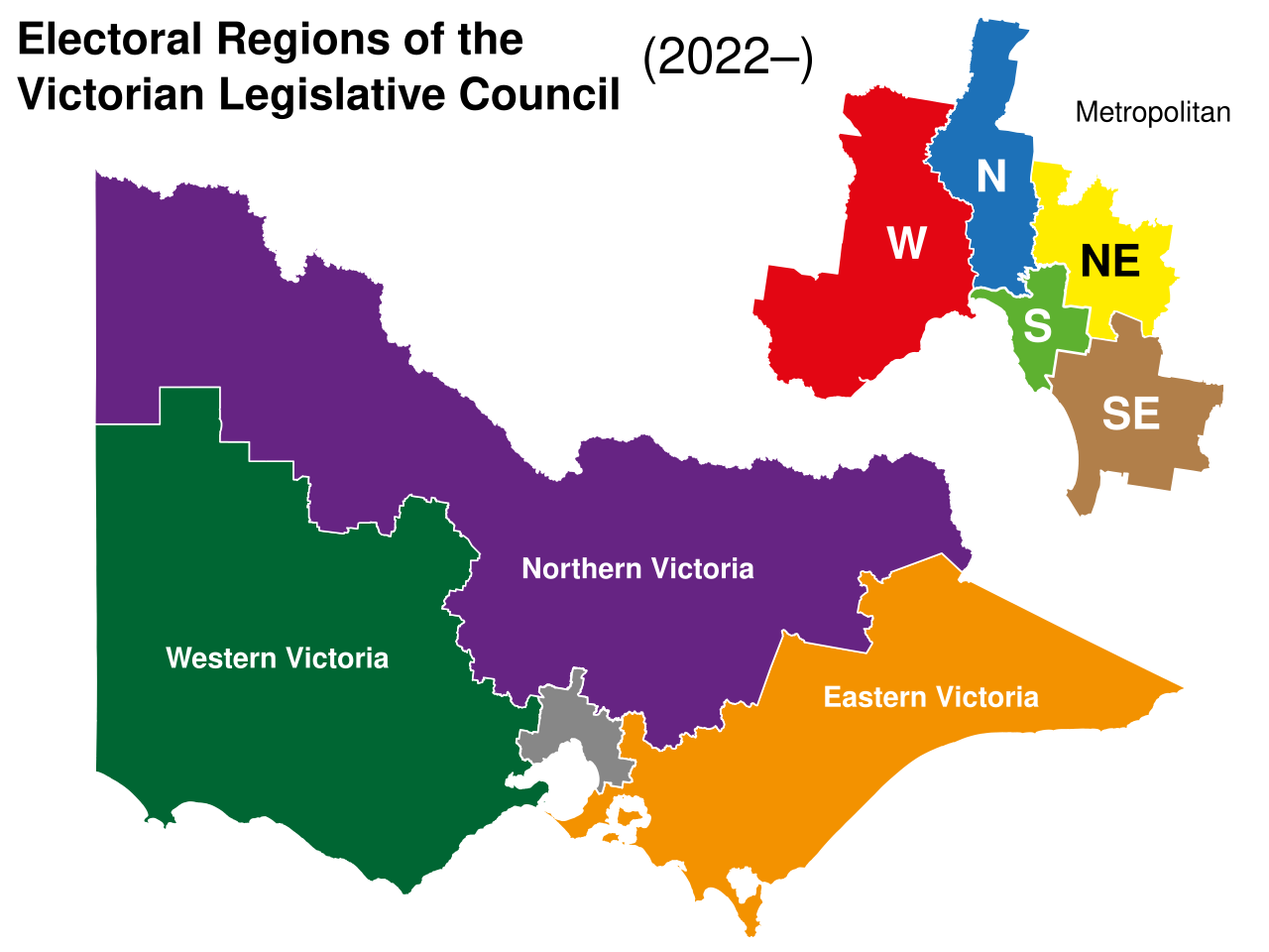
Map of Victoria’s regions
Geographic map of the eight Legislative Council regions (2022 boundaries, in force for 2026). Colours mark regions; the schematic diagram above is for quick navigation only.
.svg)
How the regions came about
For most of its history the Legislative Council was organised differently — as provinces with staggered terms and, for long periods, a restricted franchise. Reform in the early 2000s replaced that system.
From the 2006 state election, Victoria has used eight multi-member regions, each returning five members at a general election by proportional representation (group voting tickets were later abolished; today’s ballots use optional preferential above-the-line voting under current law — always check the VEC for the rules in force).
The pattern is fixed: five metro regions covering greater Melbourne and three large country regions (Northern, Eastern and Western Victoria). The 2021 redivision redrew district lines inside those regions and adjusted region edges so each still holds eleven Assembly seats; one region name was updated in that process. Those boundaries applied at the 2022 election and remain in force for 2026.
- Five metropolitan regions — denser population, small land area: Northern, Southern, North-Eastern, South-Eastern and Western Metropolitan.
- Three non-metropolitan regions — Northern, Eastern and Western Victoria: most of the state’s land mass, including regional cities and vast rural districts such as Mildura, Lowan and Gippsland East.
- Equal seats, unequal land — every region elects five MLCs, but country regions cover far more square kilometres. Representation is by enrolled electors, not by area.
Land area by region
Sum of the land area of the 11 Assembly districts in each region (Wikipedia district areas, not census population). Enrolment is rebalanced at each redivision so regions have similar numbers of electors even when area differs.
| Region | Type | Land area (km²) | Share of state | Council seats |
|---|---|---|---|---|
| Northern Victoria | Non-metropolitan | 102,169 | 44.9% | 5 |
| Western Victoria | Non-metropolitan | 77,796 | 34.2% | 5 |
| Eastern Victoria | Non-metropolitan | 44,422 | 19.5% | 5 |
| Western Metropolitan | Metropolitan | 1,299 | 0.6% | 5 |
| South-Eastern Metropolitan | Metropolitan | 659 | 0.3% | 5 |
| Northern Metropolitan | Metropolitan | 605 | 0.3% | 5 |
| North-Eastern Metropolitan | Metropolitan | 508 | 0.2% | 5 |
| Southern Metropolitan | Metropolitan | 251 | 0.1% | 5 |
| Victoria (88 districts) | 5 metro · 3 country | 227,709 | 100% | 40 |
All 8 regions
-
Eastern Victoria
5 MLCs · 11 Assembly districts · 44,422 km²
-
North-Eastern Metropolitan
5 MLCs · 11 Assembly districts · 508 km²
-
Northern Metropolitan
5 MLCs · 11 Assembly districts · 605 km²
-
Northern Victoria
5 MLCs · 11 Assembly districts · 102,169 km²
-
South-Eastern Metropolitan
5 MLCs · 11 Assembly districts · 659 km²
-
Southern Metropolitan
5 MLCs · 11 Assembly districts · 251 km²
-
Western Metropolitan
5 MLCs · 11 Assembly districts · 1,299 km²
-
Western Victoria
5 MLCs · 11 Assembly districts · 77,796 km²
Area figures from district land areas on Wikipedia’s electoral districts list (accessed 2026-07-30). Official boundary maps and live enrolment: VEC. Main 2026 upper-house index: Legislative Council.